
Visual Records of the late 19th Century Pilgrimage Route
in the Holy Land
The number of visitors to the Holy Land - pilgrims and tourists - rose to many thousands
per year during the second half of the 19th century. By the beginning of the 20th century,
their numbers exceeded ten thousand every year. The increase in numbers was fueled by political changes that facilitated access to this region, which was then dominated by the Ottomans, as well as by the availability of suitable transportation, in particular shipping lines that frequented the eastern part of the Mediterranean. Other factors were an improvement in security conditions and of the country’s infrastructure - roads, hospices, hotels and tourist services
in general.
A visit to the Holy Land usually lasted two to three weeks. Pilgrims and tourists - excited by the encounter with sites and events described in the Holy Scriptures, and shocked by the desolation, the ruins and the neglect they observed in the Land of the Bible - recorded their impressions in books, travel diaries, letters and postcards. A few brought along photo equipment (black and white, of course) or drawing utensils – sketchbooks, pencils and water colors. Most bought readymade souvenirs: photos, photo albums and in particular, painted and picture post cards, which were the most popular means of communication at the time.
This article is intended to examine whether or not it is possible to reproduce the scenes and landscapes of the pilgrimage route of the Holy Land during the second half of the 19th century and the beginning of the 20th century through the visual records that exist in diaries of travelers, collections of photographs and painted and photographed postcards of that period.
Most visitors - Christians and Jews - arrived from the USA and Europe. The pilgrimage by Russian Provoslavs was another matter altogether and will only be touched upon here sporadically. The reasons for visiting the Holy Land was expressed very well by Archie Bell (March 1914): "There are two kinds of pilgrims to the Holy Land. Some journey to Palestine from religious motives, while others go because by nature they are wanderers over the face of the earth." Visitors arrived with spiritual and cultural baggage, influenced by a decent knowledge of the Holy Scriptures, mostly the New Testament, but with little information with regard to the local conditions. Thus, many expected to arrive in the Land of the Bible, not taking into account that fact that time had dramatically changed the face of the country and its inhabitants. Reality, of course, was different and another matter altogether.
During the 19th century and up to the thirties of the 20th century, Jaffa was the main sea port and entrance to the Holy Land and to Jerusalem. Ships would arrive in Jaffa at dawn and anchor at least one kilometer from the coast, beyond the reefs that prevented ships from entering the anchorage. Here, from the ship's deck, usually bathed in the first light of the rising sun, the visitors first saw the outline of the Palestinian coast. Elisabeth Butler, arriving in the spring of 1902, wrote in her diary: "I beheld the lovely coast of the Land of Christ a mile distant, with the exquisite town of Jaffa, typically Eastern, grouped on a rock by the sea, and appearing above huge heaving waves, those grey blue tones were mixed with the rosy reflections from the clouds."
Passengers and cargo were unloaded from the ship to rowboats manned by experienced Arab seamen. The saga of landing in Jaffa and rowing among crashing waves to the anchorage appears in most travel books. The orientalist Gustav Bauernfeind dramatically painted the scene on colored postcards, showing rowboats laden with passengers making their way to the anchorage of the Jaffa port through threatening rocks and high waves.


Scenes of Jaffa, its dirty, narrow and noisy alleys were the first encounter with the Orient by most of the bewildered tourists. Only a few, mainly devoted Christians, spent more than a few hours in Jaffa. The town was simply the starting point for the journey. The row of hotels and boardinghouses of the American-German colony at the edge of the city were the preferred place for breakfast, sleeping arrangements, and in particular, to meet up with the guide - the Dragoman - and his team. He was usually a local Christian, fluent in European languages and knowledgeable about local customs and the way the rulers operated. His oriental appearance and dress were meant to fulfill the expectations of the tourists with regard to a guide in the Orient.
During the second half of the 19th century, a number of tourist companies operated to serve groups and individuals who wished to visit the Holy Land. Thomas Cook & Sons was the best-known in this field. Most visitors travelled throughout the country accompanied by a guide, a crew of helpers that included a cook and at times, an armed guard as well. The conditions of road infrastructure dictated riding on mules, while the staff walked or used donkeys to carry the luggage. Travel by carriage was limited to paved and maintained roads. There were only a few European-style hotels and most of them were in Jaffa, Ramle, Jerusalem, Nazareth, Tiberias and Haifa, managed by the Templars. A practical alternative was sleeping in well-equipped tents, which were set-up every night by the crew.
The pilgrimage and tourism route in the Holy Land was dictated primarily by the locations of holy and historical sites, adequate roads and the security situation in the region. The classical route started in Jaffa and climbed to Jerusalem - the climax of the visitors’ trip. The visit in the town lasted from a few days to a week and included selected sites around the walls of the Holy City. Bethlehem and Hebron were part of the Southern route, from where one could descend to Jericho, the Jordan River and the Dead Sea via the desert. The road then ascended back up to the Mount of Olives, then north through Nablus and the Jezreel Valley to Nazareth, Tiberias and around the Sea of Galilee. The journey ended either in Haifa, or continued north to Beirut.
Pilgrims and tourists reached Jerusalem via two principal routes:
a) The ancient Jaffa-Jerusalem road, which was reasonably paved, through the orchards of the Plain of Sharon, the towns of Lydda, Ramle, the Ayalon valley, Bab-el-Wad and Abu Gosh to the outskirts of Jerusalem and the Jaffa Gate. Riding a mule, this journey took eight to ten hours.


b) The Jaffa-Jerusalem railroad track was inaugurated in 1892, crossing Lydda and the Sorek Valley and arriving at the outskirts of Jerusalem, south of Mishkanot Sha’ananim. After four hours on the winding track, the passengers had their first glimpse of the Holy City, crossing the Sultan’s Pool along the walls of the city and arriving at the Jaffa Gate.
Carriages and camels were stationed in the square outside the Jaffa Gate, ready to transport passengers and cargo southward and westward. The elegant Sabil (water source), erected nearby in 1900 stood there. It was destroyed in the early 1920s.
The gate itself was the main entrance to the Holy City. In 1898, the city wall was breached next to the gate to enable easy passage for the Kaiser's mounted entourage. A clock tower was erected atop the gate in 1907 in honor of the ruling Sultan, Sultan Abdul Hamid the Second. This clock tower too was removed in the early 1920s (both were considered inappropriate and "kitsch" by the British rulers). Jerusalem’s trade center slowly spread in the inner courtyard of the gate, gradually moving outside of the walls, along the Jaffa Road westward.
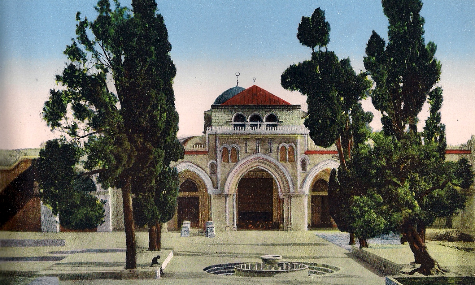
Pilgrims and most of the tourists began their visit in the Christian quarter, passed the Hezekia pool, where the level of stored water changed according to the seasons, past the Church of the Redeemer, inaugurated in 1898, arriving at the entrance of the Holy Sepulchre, weaving their way around hawkers selling all kinds of souvenirs.


Following the visit to the Church, the visitors turned to follow the Via Dolorosa, ending up at the ruins of the Bethesda pool.
Jewish and Christians tourists followed David Street, which leads from the Jaffa Gate, to the Temple Mount and the Wailing Wall. The sight of the Jews praying at the Wall left the visitors with mixed feelings. For examples, in his travel book, Richard Penlake, who visited Jerusalem in 1913, writes: "Wailing place is of pathetic interest…Here in a kind of courtyard, above which towers the old wall of the temple, the Jews - of both sexes and of all ages - congregate in order to lament the suffering of their race…. When wailing they do not care to strangers stand watching them, …. But some strangers do stand and watch them, and some are ill mannered enough to laugh, which is very wrong."


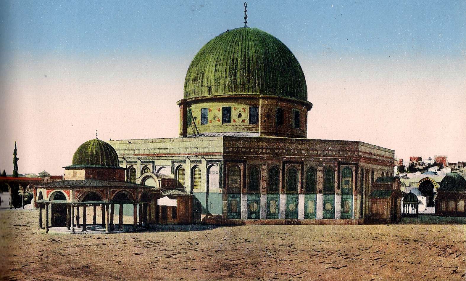
From there, despite the restrictions imposed by the authorities, most of the tourists entered the courtyard of the Temple Mount, identified by some of them as the location of the ancient Temple.
The visit of the Holy City, especially the Jewish Quarter, which stood out because of its neglect, left a negative impression upon the visitors. The crowded and noisy markets, the narrow and filthy alleys where pedestrians mingled with donkeys and camels, and above all the smells and noise, were a complete contrast to the spiritual elation that the pilgrims had anticipated. Richard Penlake described it thusly: "This street, like David street, ends in the perfect maze of dismal and vaulted streets that occupy most of the city, and it is a very easy matter to get lost in them…..Most of the streets are so narrow that it is impossible for two heavily laden donkeys to pass one another. There are no paths or drains in the streets. Foot passengers have to get out of the way, and very quickly too, when mules, camels, and donkeys come along…..There are no scavengers, and the streets are very dirty, filled as they are with garbage and the dust and dirt of centuries…..
The excursions around the walls were a compensation - a tour around the City walls and gates, the Kidron Valley, the Jehoshaphat Valley and Gethsemane, the Mount of Olives and its sacred sites, the Pool of Shiloh and the holy places on Mount Zion.
The visit of Jerusalem and its environs was the highlight of the pilgrimage and was given a prominent place in diaries, letters and travel books. Most writers attempted to blend their own beliefs and tradition with sights in the country and in Jerusalem, the residents and their way of life. It was easy to see the villagers - peasants and shepherds - as well as merchants and craftsmen, as characters coming straight out of the Holy Scriptures.
The disparity between the standard of living to which the visitors from the USA or Europe were accustomed to see and the one presented in the Eastern country only strengthened the feeling that they were experiencing scenes similar to those in the Bible and the days of the Second Temple. In her book, Elizabeth Taylor wrote: "I can best describe the fascinating quality of our journey [to the Holy Land] by saying that it is like riding through the Bible. At every turn one finds some hint that sheds light onto some Old or New Testament text.” In extreme cases, which still occur today, pilgrims became confused and suffered from a disorder known as the "Jerusalem Syndrome".
The negative aspects, the dirt, the noise and neglect were associated by the visitors with the Ottoman rulers, who in any case, already had a bad reputation in the West. Cunningham Geike, who visited the country in autumn of 1886, summarized his voyage in these words: "The future of Palestine no one can foresee. That any considerable number of Jews will ever return is most improbable. The Hebrew does not take kindly to agriculture…. The future of the land, it appears to me, belongs to the hardy fellahin, if ever Divine mercy delivers it from the baleful presence of the Turk……and will bring it under the life-giving protection of some Christian Power."
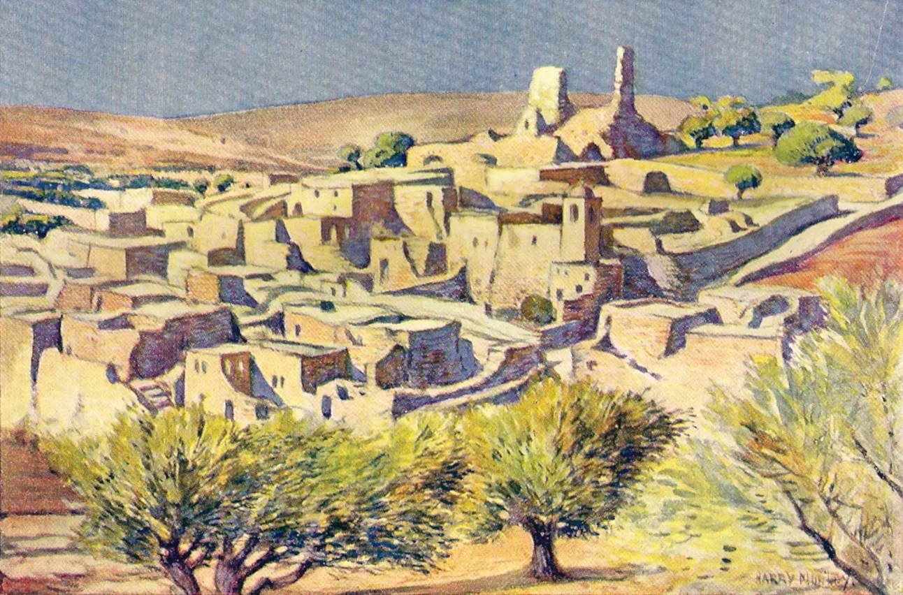
From Jerusalem, the pilgrimage route led southward to Bethlehem. Rachel's tomb, sacred to the three monotheistic religions, is mentioned by all visitors. Bethlehem and the Church of Nativity were the focus of all Christian visitors and filled them with reverence. In comparison with most of the other historical sites, some aspects of this town were also the recipient of favorable criticism.
From there, they continued south to Bethlehem, passing Solomon’s Pools and Abraham's Oak. One of the routes to Jericho and the Wadi Kelt monasteries passed the Mar-Saba monastery and across the Judean desert.
In spite of the difficulties of the desert route and heavy heat, visitors to Jerusalem did not want to miss going down to the Jordan River, the site of Christ's baptism and the place where the tribes of Israel crossed into the land of Canaan.


Jericho, a small and neglected site, is mentioned due to the nearby Spring of Elisha and a few hotels which served as a resting place or for an overnight stay.
The Jordan River was described with mixed feelings, especially in the summer months. Was this indeed the revered river mentioned in the Scriptures? American and European tourists considered it only a creek…. Reverend James Kean, who visited in March of 1891, wrote: "To say that your first sight of the Jordan is disappointing would be to use a mild expression. Coming suddenly upon this mud-banked, yellow, eddying torrent, no more of it being visible than the bit where the trees and bushes that fringe its banks have been cleared to let the bathers approach, is to experience a rude shock. This is not the Jordan you had pictured to yourself…. This is the most dreadful river you have seen…"
In spite of the terrible heat, often described as "unbearable", and which was graphically portrayed on painted landscapes in purple, red and orange hues, most tourists visited the northern tip of the Dead Sea to observe its lifeless shores and landscape which gave it its name.
The visitors left the Jordan Valley and climbed back via the Jericho-Jerusalem road, visiting the Inn of the Good Samaritan and the village of Bethany (El-Azaria) in passing - all sacred Christian sites.
The view from the Mount of Olives westward towards Jerusalem is magnificent and has been recorded in hundreds of photographs and drawings. One of the most impressive among them was painted by the German Orientalist Gustav Bauernfeind, who was buried in Jerusalem in 1904.
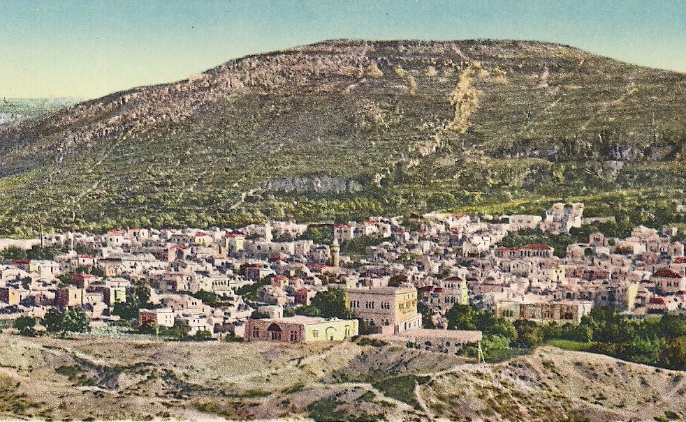
The pilgrimage route continued northward along the mountain ridge passing the ruins of Shiloh, the town of Nablus and traditional Christian sites such as Jacob's Well and Samaria (Sebastia). The road crossed the desolate valley of Jezreel, overlooked Mount Tabor, climbing to Nazareth, the birthplace of Jesus.


Following a brief tour of Nazareth, the road turned east to Cana which, according to Christian tradition, was the site of the miracle of turning water into wine. The road then descended in the direction of Tiberias and the "Sea of Galilee".
The town of Tiberias had been partially destroyed as a result of a severe earthquake that had hit at the beginning of the 19th century. At most, the town served as a way station to the lake and the sacred Christian sites around it. These sites, including Magdala, the site of the Sermon on the Mount, Tabgaha and Capernaum were the target of pilgrims who walked, rode mules or sailed on the lake to experience the New Testament.
The journey in the Holy Land usually ended in the north, with the tourists also visiting the source of the Jordan River and of course, the ruins of the city of Banias. The preferred point of departure in the north was the port of Beirut, an important station for all European shipping lines on the Mediterranean. Others left the country via Haifa, where the German Colony provided the tired pilgrims plenty of food and rest.
Many of the visitors to the Holy Land felt the need to share their experience – be they positive or negative - with friends, members of their religious community or the public as a whole. Based on the interest shown in the Holy Land by the Western world between 1880 and 1914, a rich and varied visual documentation was established, which was based upon the most recent technological innovations of the time:
a) Black and white photographs, photo albums, stereoscopic photos, hand-colored photos. The technology of photography, invented in the forties of the 19th century, developed rapidly during that period, with the development of portable cameras, optics, photo plates and later into also film.
b) The publication of travel books with pictures and paintings became simpler and less expensive with the development of offset, lithography and color separation printing technologies.
c) The developments in printing also affected the publication of black/white photo albums printed in color. The establishment of the universal postal services and the invention and adoption of the postcard turned black/white, color picture postcards and Orientalist drawings into the most popular communication means of the era.
These days, where visual communication is all digital, in color - video and films - it is particularly important to remember the contribution of Holy Land visual records created in the second half of the 19th century and early 20th to the study of the country and its inhabitants.